Waterfalls in Banff National Park: Postcard Perfect Views
The waterfalls of Banff National Park offer postcard-perfect views that are a must to witness with your own eyes. In this blog post, I’ll take a closer look at the ten most beautiful AND easily accessible waterfalls in Banff National Park.
Imagine yourself strolling in a forest when you suddenly hear the thundering sound of water tumbling from a cliff. The sound only gets louder as you go closer. The noise of the rushing water promises a breathtaking scene that will soon be revealed to you, adding excitement to your hike.
In Banff, you can have this experience at several locations. There are quite a few easily accessible waterfalls that are absolutely worth checking. I listed them for you below. Let’s check it out.
Banff Waterfalls: a Brief Overview
Below, you’ll find a concise overview of the waterfalls in this article. They are listed in the order you will more or less encounter them when you enter the park near Canmore.
| WATERFALL | HEIGTH | FREEZES | WHEN TO VISIT |
|---|---|---|---|
| Bow Falls | 9 m (30 ft) | ✓ | Year-round |
| Sundance Canyon Falls | 50 m (164 ft) | ✗ | May – October |
| Cascade Falls | 300 m (984 ft) | ✓ | May – October |
| Johnston Canyon Lower Falls | 10 m (33 ft) | ✓ | Year-round |
| Johnston Canyon Upper Falls | 30 m (98 ft) | ✓ | Year-round |
| Silverton Falls | 50 m (164 ft) | ✗ | May – September |
| Lake Agnes Falls | 11 m (36 ft) | ✗ | June – October |
| Bow Glacier Falls | 154 m (505 ft) | ✗ | June – October |
| Mistaya Canyon Falls | 12 m (40 ft) | ✗ | May – October |
| Weeping Wall | 360 m (1180 ft) | ✗ | Year-round |
| Panther Falls | 66 m (217 ft) | ✓ | May – September |
| Bridal Veil Falls | 370 m (1213 ft) | ✗ | May – September |
Cascade Falls

Cascade Falls is the name giver of Cascade Mountain and, with a drop of 290 meters (951 ft), the third-highest waterfall in Alberta. The falls are easily accessible and can be reached via a short hike from the nearby parking lot, although the trail has some steeper parts.
The trailhead is close to the Trans-Canada Highway’s Banff/Minnewanka Loop/Boucle Minnewanka exit. Due to its proximity to the town of Banff and its accessibility, Cascade Falls is popular among tourists. The trail to the falls follows the Cascade River. It’s well-maintained and easy to navigate.
The easy hike to the falls is about a 1-kilometer (0.62 mi) round trip and takes about 30 minutes to complete. Its accessibility makes it an excellent option for families with small children or people with limited mobility.
Getting There
Cascade Falls can be reached from the small parking lot just off the Lake Minnewanka Scenic Drive intersection and the road to Cascade Ponds. The parking lot is just two hundred meters north of the Trans-Canada Highway.
Bow Falls

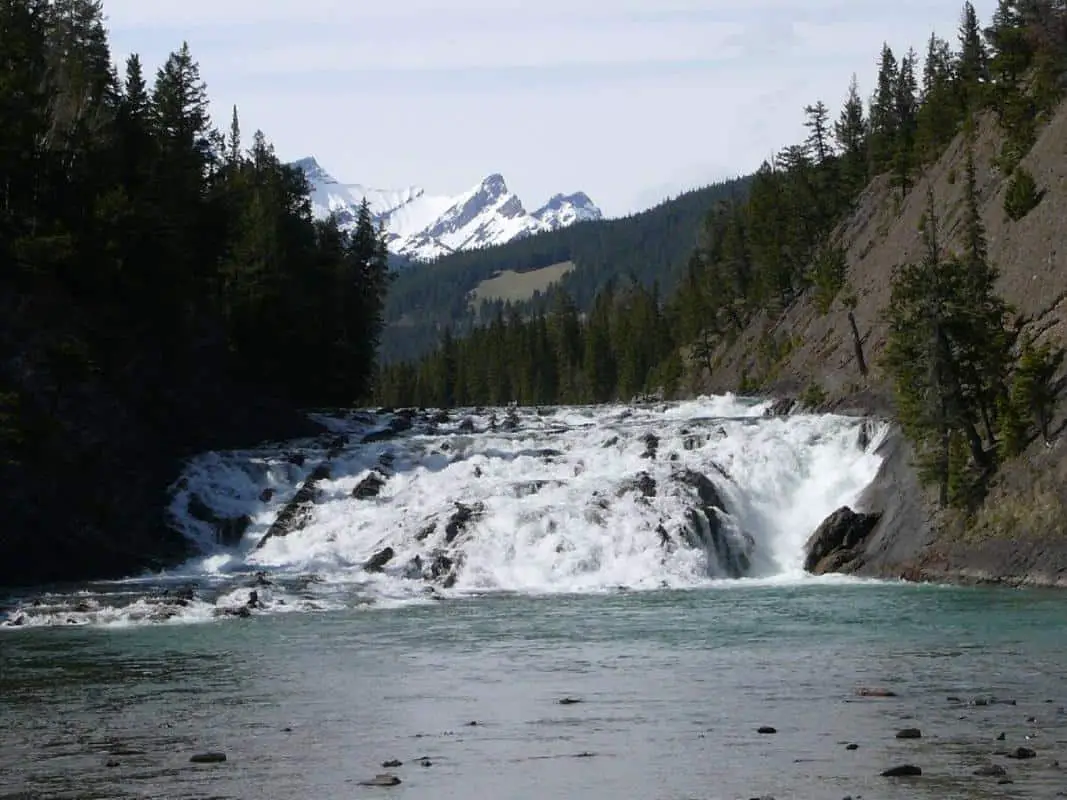
The Bow Falls is probably the most famous cascade of Banff National Park. It’s located on the Bow River, just a short distance from the town of Banff. The falls drop about 15 meters and are popular with tourists and locals as they are easily accessible via a short walk from the parking area. They offer an excellent spot for photography and picnics. The area provides a variety of activities, including hiking, golfing, and rafting. So, if you want, you could spend an entire day here.
Getting There
The Bow Falls are just a short distance from the town of Banff. If you want to walk to the falls, take the Bow River Trail just before the Banff River Bridge in the south (at the end of Banff Avenue). The trail is a 1.5 km (1 mile) return hike that takes around 30 minutes to complete.
You can enjoy views of the Bow River and the surrounding mountains along the way.
It is also possible to reach the falls by car through Bow Fall Avenue., There is a parking lot near the Bow River, right behind the Fairmont Banff Springs Hotel.
Sundance Canyon Falls

The Sundance Canyon waterfall is fed by Sundance Creek and is approximately 40 meters (130 feet) tall, divided into multiple sections. The waterfall is a popular with hikers and is relatively easily accessible.
It offers incredible scenery and beautiful canyon views. The bridge over the waterfall is a nice feat, providing a view up and down the waterfall. Although it’s not the biggest waterfall in the park, the fact that it’s in a canyon makes for a spectacular view.
The hike to the falls can be a bit boring initially. The Sundance Trail has a 3.68 kilometers (2.29 mi) paved section before you enter the actual canyon. The waterfall is located near the beginning of the trail’s forested portion.
A good idea is to cycle to the forested section. At the end of the road, there are some bike racks.
Getting There
The trailhead of the Sundance Trail is easy to find. It starts at the other end of the Cave and Basin parking lot near the town of Banff.
Johnston Canyon Lower and Upper Falls

The Johnston Canyon Falls is located in the Johnston Canyon area and is a hugely popular tourist destination. There are two falls in Johnston Canyon: the Lower Falls and the Upper Falls.
It is a short hike to the lower falls and a longer hike to the upper falls. The lower falls are a set of cascading falls that drop about 25 meters, while the upper falls drop about 45 meters. The hike to the upper falls is a bit more strenuous, but it offers a more secluded and peaceful experience.

Set in a stunning canyon, you’ll be impressed by the surrounding scenery, making this a very Instagram-worthy spot. So don’t forget to bring your camera or smartphone.
The trail is fenced, partially paved, and stroller-accessible, making it a worthwhile hike for people of all ages.
Getting There
If you’re coming from the direction of Banff, drive for about 17 km (10.6 mi) on the Bow Valley Parkway. You’ll find the Johnston Canyon parking lot on your right-hand side.
If you’re coming from the direction of Lake Louise, you’ll get onto the Bow Valley Parkway at the other end. From there, it’s about 33 kilometers (20.5 mi) to get to the parking lot.
Wanna learn more about Johnston Canyon, check the guide to Johnston Canyon!
Silverton Falls

The Silverton Falls are located not far from the Bow Valley Parkway. When you reach the falls, you’ll be rewarded with a breathtaking view of the cascading water falling from a height of about 50 meters (165 ft). The falls can only be accessed by hiking the relatively short Rockbound Lake Trail (1.8 km or 1.1 mi). A well-worn and easy-to-follow trail leads you up Castle Mountain toward the falls.
The trail to the falls takes about 40 minutes to complete and is typically considered easy. You can continue to Rockbound Lake from the falls if you so desire.
Getting There
You can access the trail from the parking lot just off the Bow Valley Parkway, opposite the HI Castle Mountain Wilderness Hostel.
Lake Agnes Falls

Lake Agnes Falls is a popular destination for hikers. The waterfall can be accessed via a moderate hike from the nearby Lake Louise parking lot.
The hike to the waterfall is a 7.4-kilometer (4.6 mi) round trip and takes about 2-3 hours to complete. The trail to the waterfall is well-maintained and easy to follow. It starts by following the shoreline of the iconic Lake Louise, offering stunning views of the lake and the surrounding mountains.
The trail climbs through a dense forest, providing a cool summer shade. When you reach the waterfall, you’ll be greeted with a beautiful and serene view of the cascading water falling from a height of about 20 meters.
The waterfall is a great place to relax and enjoy the area’s natural beauty. You can also enjoy the nearby tea house. It serves sandwiches, hot and cold drinks (like tea, obviously), and homemade cookies.
Getting There
Take the exit at Lake Louise Village on the Trans-Canada Highway (Highway 1) to Lake Louise. Once at the lake, park in the parking lot. From there, you can start your hike to Agnes Falls.
Caveat: If you plan to hike to the falls, be aware that the Lake Louise parking lot fills up quickly in the summer. You will need to arrive early (BEFORE 7 a.m.) to secure a parking spot. You can also take public transportation to the lake or park near the ski area. From there you can take a shuttle bus to the lake. However, you need to book a shuttle ticket (well) in advance.
Wanna read more about parking at Lake Louise? Click the link.
Bow Glacier Falls

The Bow Glacier Waterfall is an excellent option for a more challenging hike. The hike’s beginning is simple, but later – beyond the rock slide – it becomes rather tough to reach the waterfall. This hike is a 10 km (6.2 mi) round trip and takes about 3-4 hours to complete.
The trail to the waterfall is not well-maintained. It hugs the Bow Lake shoreline for a while and offers beautiful views of the surrounding mountains. It also provides a view of the falls in the distance, thundering down, right under the Bow Glacier. The trail can be challenging, especially when you get close to the waterfall.
When you reach the waterfall, you’ll be rewarded with a breathtaking view of the cascading water falling from an impressive height of 154 meters (505 ft).
It might well be the most impressive waterfall in this overview. The falls are surrounded by rugged and snowy mountains, making them a spectacular natural attraction. You can also see two much smaller waterfalls to your right, making the scene even more grandiose.
Getting There
You can park your car on either the pull-out along the Icefields Parkway or – a little closer – on the side of the road leading up to the Num-Ti-Jah Lodge or the Bow Lake Car Lot on this road.
ALSO READ: Comprehensive guide to Bow Lake
Mistaya Canyon Falls

Mistaya Canyon Falls is a spectacular waterfall fed by the Mistaya River (originating in Peyto Lake) in an even more spectacular backdrop. The canyon’s main waterfall is approximately 12 meters (40 ft) high and is surrounded by steep rock walls. The canyon is also home to several smaller waterfalls and rapids, making it a popular spot for hiking and photography.
Getting There
Mistaya Canyon is easy to reach, as it’s just off the Icefields Parkway. You can park your car on the pull-out next to the highway. From there, you can hike to the canyon. It’s just a 1-kilometer round trip along a relatively wide and easy trail. It’s accessible for strollers. However, the numerous trails beyond the bridge that spans the canyon are smaller, rockier, and occasionally covered in tree roots.
Weeping Wall

The Weeping Wall is a rock formation along the Icefields Parkway. You don’t need to hike there, as you can see it from the road. The Weeping Wall is either a smaller waterfall cascading over the brink of a tall cliff (in summer) or a more significant waterfall (in spring), supported by several other lesser falls along the ridge. I’d suggest stopping here at the very least for a quick photo because there is a viewpoint next to the road.
Getting There
Getting to the Weeping Wall is easy as its viewpoint is conveniently located along the Icefields Parkway. There’s a pull-out on the opposite side of the road, allowing you to park your car and admire the waterfall.
Panther and Bridal Veil Falls

You can access both the Panther and Bridal Veil Falls through one trail. The trailhead is close to the Icefields Parkway, just after the famous Big Bend.
The relatively easy hike, including both falls, is about 1.3 km (0.81 mi) and takes about an hour to 75 minutes to complete. It’s a rewarding short trip to stretch your legs after a long drive on the Icefields Parkway.
The Panther Falls is 66 m (217 ft) high, and the Bridal Veil Falls is an impressive 370 meters (1200 ft) tall and originates in the Huntington Glacier on the slopes of Cirrus Mountain.

To get to the Bridal Veil Falls from Panther Falls, you walk down from Panther Falls to Nigel Creek.
Good to know: Most tourists driving the Icefields Parkway skip these waterfalls, probably not knowing they’re there.
Getting There
There is a very large pull-out next to the Icefields Parkway, where you can comfortably park your car and start the hike to the falls. The trailhead is at the southeast end of the car park.
The area around the Panther and Bridal Veil Falls has a lot to offer. You can read everything you need to know in my (very) extensive guide on the Icefields Parkway. Check it out!
Map
Below, you’ll find a map indicating all twelve waterfalls I listed above.
Distances Table
Below you’ll find a distances table, indicating the distance to every waterfall mentioned from the towns of Banff and Lake Louise.
| WATERFALL | DISTANCE FROM BANFF | DISTANCE FROM LAKE LOUISE |
|---|---|---|
| Cascade Falls | 6.8 km (4.2 mi) | 62 km (39 mi) |
| Bow Falls | 1.6 km (1.0 mi) | 60 km (37 mi) |
| Sundance Canyon Falls | 2.3 km (1.43 mi) | 60 km (37 mi) |
| Johnston Canyon Lower Falls | 32 km (20 mi) | 35 km (22 mi) |
| Johnston Canyon Upper Falls | 32 km (20 mi) | 35 km (22 mi) |
| Silverton Falls | 40 km (25 mi) | 29 km (18 mi) |
| Lake Agnes Falls | 69 km (43 mi) | 4.4 km (2.73 mi) |
| Bow Glacier Falls | 103 km (64 mi) | 41 km (25 mi) |
| Mistaya Canyon Falls | 137 km (85 mi) | 37 km (23 mi) |
| Weeping Wall | 171 km (106 mi) | 109 km (68 mi) |
| Panther Falls | 178 km (111 mi) | 116 km (72 mi) |
| Bridal Veil Falls | 178 km (111 mi) | 116 km (72 mi) |
